


Les Gets - Le Grand C4y

sandrine-s01
User
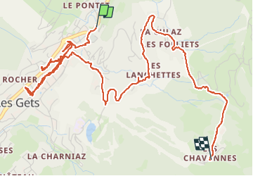

Length
7.2 km

Max alt
1492 m

Uphill gradient
352 m
Km-Effort
10.8 km

Min alt
1159 m

Downhill gradient
26 m
Boucle
No
Creation date :
2025-08-14 08:36:44.235
Updated on :
2025-08-14 11:16:42.207
2h01
Difficulty : Easy

FREE GPS app for hiking
 SityTrail
IGN / Geographical institutes
SityTrail Plus
The world is yours!
About
Trail Walking of 7.2 km to be discovered at Auvergne-Rhône-Alpes, Upper Savoy, Les Gets. This trail is proposed by sandrine-s01.
Positioning
Country:
France
Region :
Auvergne-Rhône-Alpes
Department/Province :
Upper Savoy
Municipality :
Les Gets
Location:
Unknown
Start:(Dec)
Start:(UTM)
320352 ; 5114621 (32T) N.
Comments